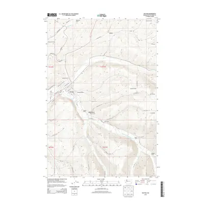
2014 Map of Dayton
USGS Topo · Published 2014About this map
Dayton serves as the focal point of this 2014 survey, where the Touchet River meets the Patit Cr in southeastern Washington. The street grid of the town is detailed down to individual thoroughfares like W Dayton Ave and E Washington Ave, showing the density of the settlement within the larger Touchet Valley. To the south, the smaller community of Baileysburg sits at the junction of Davis Hollow and the river, marking a distinct residential pocket separate from the main town center.
Find a feature on this map
64 named features on this map. Tap any name to fly to it.
Don’t see what you’re looking for? This feature index may not catch every label — zoom into the map to look around manually.
Map Details
Editions of this 2014 Dayton Map
This is the sole edition of this map. No revisions or reprints were ever made.
Other maps of this area

1919 · Walla Walla
USGS Topo · 1:125,000

1921 · Walla Walla
USGS Topo · 1:125,000

1937 · Pomeroy
USGS Topo · 1:96,000

1942 · Pomeroy
USGS Topo · 1:125,000

1953 · Walla Walla
USGS Topo · 1:250,000

1955 · Pullman
USGS Topo · 1:250,000

1958 · Pullman
USGS Topo · 1:250,000

1958 · Walla Walla
USGS Topo · 1:250,000
1966 · Coppei
USGS Topo · 1:24,000
1967 · Robinette Mtn.
USGS Topo · 1:24,000