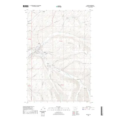
2020 Map of Dayton
USGS Topo · Published 2020About this map
Dayton serves as the central hub of this Columbia County survey, situated where the Touchet River meets its tributaries. The town’s street grid is clearly defined, featuring prominent thoroughfares like E Main St and W Commercial St, while the nearby Dayton Cem provides a point of interest for those tracking local lineages. The surrounding landscape is characterized by a series of deep drainages and hollows, including Mustard Hollow, Johnson Hollow, and Whetstone Hollow, which illustrate the complex topography of the region.
Find a feature on this map
75 named features on this map. Tap any name to fly to it.
Don’t see what you’re looking for? This feature index may not catch every label — zoom into the map to look around manually.
Map Details
Editions of this 2020 Dayton Map
This is the sole edition of this map. No revisions or reprints were ever made.
Other maps of this area

1919 · Walla Walla
USGS Topo · 1:125,000

1921 · Walla Walla
USGS Topo · 1:125,000

1937 · Pomeroy
USGS Topo · 1:96,000

1942 · Pomeroy
USGS Topo · 1:125,000

1953 · Walla Walla
USGS Topo · 1:250,000

1955 · Pullman
USGS Topo · 1:250,000

1958 · Pullman
USGS Topo · 1:250,000

1958 · Walla Walla
USGS Topo · 1:250,000
1966 · Coppei
USGS Topo · 1:24,000
1967 · Robinette Mtn.
USGS Topo · 1:24,000