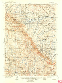
1901 Map of Dayton
USGS Topo · Published 1949About this map
The Big Horn Mountains dominate this 1899 survey, providing a sharp contrast between the high peaks of the Sheridan Co. Johnson Co. Boundary Line and the emerging rail towns to the north. Settlement is concentrated along the Tongue River and its tributaries, where the Burlington and Missouri River R. R. connects the towns of Ranchester, Dayton, and Parkman. This era captures the landscape before major modern development, highlighting the early military presence at the Fort Mackenzie Reservation and the industrial activity at various locations labeled simply as Coal Mine. Higher elevations are marked by remote outposts and family-named landmarks like the Morrow Ranch, Tongue River Cabin, and Rockwood. Distinctive natural features such as Steamboat Pt. and Elephant Foot serve as primary navigational waypoints in a terrain where Walker Prairie sits atop the high ridges of Walker Mtn.
Find a feature on this map
69 named features on this map. Tap any name to fly to it.
Don’t see what you’re looking for? This feature index may not catch every label — zoom into the map to look around manually.
Map Details
Editions of this 1901 Dayton Map
5 editions found
Other maps of this area

1894 · Rosebud
USGS Topo · 1:125,000

1894 · St. Xavier
USGS Topo · 1:125,000

1895 · Dayton
USGS Topo · 1:125,000

1898 · Bald Mountain
USGS Topo · 1:125,000

1899 · Cloud peak
USGS Topo · 1:125,000

1900 · Fort McKinney
USGS Topo · 1:125,000

1901 · Rosebud
USGS Topo · 1:125,000

1901 · Cloud Peak
USGS Topo · 1:125,000

1901 · Dayton
USGS Topo · 1:125,000

1901 · St. Xavier
USGS Topo · 1:125,000