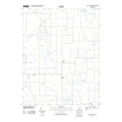
2010 Map of De Gonia Springs
USGS Topo · Published 2010About this map
De Gonia Springs and the surrounding rural landscapes of Warrick County are defined by a network of creeks and family-named cemeteries that speak to generations of settlement. In the northern reaches, Hendrickson Lake is held by the Hendrickson Lake Dam, feeding into a drainage system that includes Coles Creek and Barren Fork. The southern portion of the quadrangle follows the winding path of Little Pigeon Creek near the community of Midway. For those tracing local heritage, the map is remarkably dense with burial sites, from the larger Plainview Memorial Cemetery to smaller family plots like the Kelley Cemetery, Roth Cemetery, and Mill Cemetery. This grid of section roads, including Skelton Rd and Hible Rd, connects isolated homesteads and small agricultural clusters such as Eames in a landscape still primarily dedicated to farming and open drainage.
Find a feature on this map
76 named features on this map. Tap any name to fly to it.
Don’t see what you’re looking for? This feature index may not catch every label — zoom into the map to look around manually.
Map Details
Editions of this 2010 De Gonia Springs Map
This is the sole edition of this map. No revisions or reprints were ever made.
Other maps of this area

1900 · De Gonia Springs
USGS Topo · 1:62,500

1901 · Owensboro
USGS Topo · 1:62,500

1902 · Ditney
USGS Topo · 1:125,000

1902 · Degonia Springs
USGS Topo · 1:62,500

1902 · Boonville
USGS Topo · 1:62,500

1905 · Newburg
USGS Topo · 1:62,500

1951 · Yankeetown
USGS Topo · 1:24,000

1952 · Rockport
USGS Topo · 1:24,000

1954 · Evansville
USGS Topo · 1:250,000
1954 · Richland
USGS Topo · 1:24,000