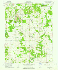
1960 Map of De Gonia Springs
USGS Topo · Published 1962About this map
The therapeutic waters of De Gonia Springs and Ash Iron Springs anchor this 1960 landscape in southern Indiana, where the boundary between Warrick Co Spencer Co is defined by the winding course of Little Pigeon Creek. The region is a mix of agricultural tradition and industrial transformation, evidenced by numerous country churches such as Bethabara Ch and Baker Chapel standing alongside active Strip Mines.
Find a feature on this map
41 named features on this map. Tap any name to fly to it.
Don’t see what you’re looking for? This feature index may not catch every label — zoom into the map to look around manually.
Map Details
Editions of this 1960 De Gonia Springs Map
2 editions found
Other maps of this area

1900 · De Gonia Springs
USGS Topo · 1:62,500

1901 · Owensboro
USGS Topo · 1:62,500

1902 · Ditney
USGS Topo · 1:125,000

1902 · Degonia Springs
USGS Topo · 1:62,500

1902 · Boonville
USGS Topo · 1:62,500

1905 · Newburg
USGS Topo · 1:62,500

1951 · Yankeetown
USGS Topo · 1:24,000

1952 · Rockport
USGS Topo · 1:24,000

1954 · Evansville
USGS Topo · 1:250,000
1954 · Richland
USGS Topo · 1:24,000