
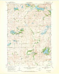
1968 Map of De Graff
USGS Topo · Published 1970About this map
The village of De Graff serves as the primary settlement on this West Central Minnesota landscape, situated along the tracks of the Great Northern railroad. The surrounding terrain is defined by a complex network of wetlands and managed natural spaces, including the Bench State Wildlife Management Area and the Camp Kerk State Wildlife Management Area. These protected zones highlight the area's significance for conservation, preserving the marshy character of the Chippewa River basin.
Find a feature on this map
23 named features on this map. Tap any name to fly to it.
Don’t see what you’re looking for? This feature index may not catch every label — zoom into the map to look around manually.
Map Details
Editions of this 1968 De Graff Map
This is the sole edition of this map. No revisions or reprints were ever made.
Other maps of this area

1953 · Saint Cloud
USGS Topo · 1:250,000

1957 · Saint Cloud
USGS Topo · 1:250,000

1958 · Saint Cloud
USGS Topo · 1:250,000

1958 · Murdock
USGS Topo · 1:24,000

1958 · Gracelock NE
USGS Topo · 1:24,000

1958 · Kerkhoven
USGS Topo · 1:24,000

1968 · Lake Hassel
USGS Topo · 1:24,000

1968 · Benson
USGS Topo · 1:24,000

1968 · Lake Simon
USGS Topo · 1:24,000
1968 · Swift Falls
USGS Topo · 1:24,000