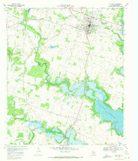
1969 Map of De Leon
USGS Topo · Published 1972About this map
De Leon serves as the primary hub of this Comanche County landscape, situated where the Texas Central railroad meets a network of local roads and an Old Railroad Grade. The terrain is defined by the winding course of the Sabana River, which feeds into the northern reaches of the Proctor Reservoir. The reservoir's impact on the local geography is evident in the submerged contours and the presence of the Spillway 1162, which altered the natural flow of Rush Creek and Copperas Creek.
Find a feature on this map
33 named features on this map. Tap any name to fly to it.
Don’t see what you’re looking for? This feature index may not catch every label — zoom into the map to look around manually.
Map Details
Editions of this 1969 De Leon Map
This is the sole edition of this map. No revisions or reprints were ever made.
Other maps of this area

1888 · Hamilton
USGS Topo · 1:125,000

1889 · Brownwood
USGS Topo · 1:125,000

1890 · Stephenville
USGS Topo · 1:125,000

1894 · Hamilton
USGS Topo · 1:125,000

1894 · Eastland
USGS Topo · 1:125,000

1894 · Brownwood
USGS Topo · 1:125,000

1920 · Stephenville
USGS Topo · 1:125,000

1954 · Brownwood
USGS Topo · 1:250,000

1954 · Abilene
USGS Topo · 1:250,000

1956 · Gustine
USGS Topo · 1:62,500