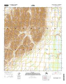
2015 Map of De Long Mountains A-1 SW
USGS Topo · Published 2015About this map
Noatak National Preserve encompasses the central and eastern portions of this landscape, where the terrain transitions from high alpine peaks to broad river valleys. The topography is dominated by the massive presence of Mt Koklak in the west, a prominent landmark that influences the drainage patterns of the surrounding highlands. This 2015 survey illustrates the hydrological network of the De Long Mountains, specifically the headwaters and tributaries that feed the Kelly River and Wrench Creek. These waterways provide a clear view of the glacial and alluvial forces shaping this arctic environment, where the land remains largely defined by natural boundaries rather than human infrastructure or permanent settlements.
Find a feature on this map
9 named features on this map. Tap any name to fly to it.
Don’t see what you’re looking for? This feature index may not catch every label — zoom into the map to look around manually.
Map Details
Editions of this 2015 De Long Mountains A-1 SW Map
This is the sole edition of this map. No revisions or reprints were ever made.
Other maps of this area

1951 · De Long Mountains
USGS Topo · 1:250,000

1951 · Noatak
USGS Topo · 1:250,000

1955 · Noatak
USGS Topo · 1:250,000

1955 · De Long Mountains
USGS Topo · 1:250,000

1955 · Noatak D-1
USGS Topo · 1:63,360

1955 · Noatak D-2
USGS Topo · 1:63,360

1955 · De Long Mountains A-1
USGS Topo · 1:63,360

1955 · De Long Mountains A-2
USGS Topo · 1:63,360

1964 · Noatak
USGS Topo · 1:250,000

1965 · De Long Mountains
USGS Topo · 1:250,000