
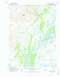
1955 Map of Noatak D-2
USGS Topo · Published 1964About this map
Sivukat Mountain dominates the northern elevation of this landscape, overlooking the expansive drainage basin of the Noatak River as it appeared in the mid-1950s. The river system is the central corridor here, winding through a complex network of wetlands and braided channels that define the interior of the Noatak quadrangle. This era of surveying by the Army Map Service reveals a largely unpopulated wilderness, though a single Cabin is recorded along a southern bend of the river, providing a rare trace of human presence in this remote Arctic environment. Tributaries like Evaingiknuk and Pingalukruk Creek flow from the surrounding highlands to join the main river valley, illustrating the natural drainage patterns that have shaped this terrain over centuries. This document reflects the baseline topography before significant modern shifts in the region's hydrography.
Find a feature on this map
6 named features on this map. Tap any name to fly to it.
Don’t see what you’re looking for? This feature index may not catch every label — zoom into the map to look around manually.
Map Details
Editions of this 1955 Noatak D-2 Map
2 editions found
Other maps of this area

1951 · De Long Mountains
USGS Topo · 1:250,000

1951 · Noatak
USGS Topo · 1:250,000

1955 · Noatak
USGS Topo · 1:250,000

1955 · De Long Mountains
USGS Topo · 1:250,000

1955 · Noatak D-1
USGS Topo · 1:63,360

1955 · Noatak D-3
USGS Topo · 1:63,360

1955 · De Long Mountains A-1
USGS Topo · 1:63,360

1955 · De Long Mountains A-2
USGS Topo · 1:63,360

1955 · Noatak C-2
USGS Topo · 1:63,360

1955 · Noatak C-1
USGS Topo · 1:63,360