
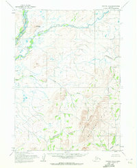
1955 Map of Noatak D-3
USGS Topo · Published 1964About this map
The Mulgrave Hills anchor the southeastern portion of this landscape, rising above a network of waterways in the Northwest Arctic. This mid-century topographical study, based on photogrammetric methods from aerial photographs taken in 1952 and 1955, shows a wilderness primarily defined by its drainage basins and isolated peaks. To the north, the Wulik River and Ikalukrok River meander through the terrain, while Iyichoruk Mountain stands as a prominent landmark. The presence of smaller tributaries like Tutak Creek, Evaingiknuk Creek, and Kuchak Creek illustrates a complex hydrological system in a region where land lines were predetermined by the Bureau of Land Management but remained unsurveyed and unmarked on the ground at the time of publication.
Find a feature on this map
7 named features on this map. Tap any name to fly to it.
Don’t see what you’re looking for? This feature index may not catch every label — zoom into the map to look around manually.
Map Details
Editions of this 1955 Noatak D-3 Map
2 editions found
Other maps of this area

1951 · De Long Mountains
USGS Topo · 1:250,000

1951 · Noatak
USGS Topo · 1:250,000

1955 · Noatak
USGS Topo · 1:250,000

1955 · De Long Mountains
USGS Topo · 1:250,000

1955 · Noatak D-4
USGS Topo · 1:63,360

1955 · Noatak D-2
USGS Topo · 1:63,360

1955 · De Long Mountains A-3
USGS Topo · 1:63,360

1955 · De Long Mountains A-2
USGS Topo · 1:63,360

1955 · Noatak C-2
USGS Topo · 1:63,360

1955 · Noatak C-4
USGS Topo · 1:63,360