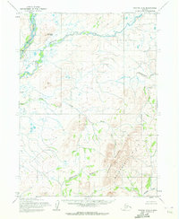
1955 Map of Noatak D-3
USGS Topo · Published 1972About this map
Mulgrave Hills and the surrounding river systems define this portion of the Noatak Quadrangle in Alaska, as mapped by the Army Map Service in the mid-1950s. The landscape is dominated by complex watercourses including the Wulik River and its various tributaries such as Ikalukrok Creek and Tutak Creek. To the south, the terrain rises significantly toward Kikmiksorak Mountain and Iyichoruk Mountain, providing a clear record of the Kateel River Meridian’s unsurveyed and unmarked land lines as predetermined by the Bureau of Land Management. The drainage patterns of Omikviorok River and Kuchak Creek illustrate a remote Arctic environment before significant modern intervention. This survey, based on aerial photographs from 1952 and 1955, serves as a primary geographic record for this section of the Northwest Arctic, where the movement of water through the hills dictates the character of the entire region.
Find a feature on this map
9 named features on this map. Tap any name to fly to it.
Don’t see what you’re looking for? This feature index may not catch every label — zoom into the map to look around manually.
Map Details
Editions of this 1955 Noatak D-3 Map
2 editions found
Other maps of this area

1951 · De Long Mountains
USGS Topo · 1:250,000

1951 · Noatak
USGS Topo · 1:250,000

1955 · Noatak
USGS Topo · 1:250,000

1955 · De Long Mountains
USGS Topo · 1:250,000

1955 · Noatak D-4
USGS Topo · 1:63,360

1955 · Noatak D-3
USGS Topo · 1:63,360

1955 · Noatak D-2
USGS Topo · 1:63,360

1955 · De Long Mountains A-3
USGS Topo · 1:63,360

1955 · De Long Mountains A-2
USGS Topo · 1:63,360

1955 · Noatak C-2
USGS Topo · 1:63,360