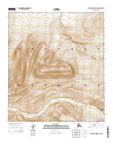
2014 Map of De Long Mountains C-2 SW
USGS Topo · Published 2014About this map
The Kukpowruk River winds through the southern reaches of this landscape in the De Long Mountains, forming the primary drainage for the area's high, undulating terrain. This 2014 survey captures a section of the North Slope defined by its lack of permanent settlements or infrastructure, organized instead by the grid of the Public Land Survey System across townships like T10s R48w and T10s R47w. The topography reveals a series of prominent ridgelines and summits that separate the river valley from the northern plateaus. This map serves as a detailed record of the natural hydrology and elevation before any modern industrial or transport development, preserving the state of this arctic watershed during the early 21st century.
Find a feature on this map
7 named features on this map. Tap any name to fly to it.
Don’t see what you’re looking for? This feature index may not catch every label — zoom into the map to look around manually.
Map Details
Editions of this 2014 De Long Mountains C-2 SW Map
This is the sole edition of this map. No revisions or reprints were ever made.
Other maps of this area

1951 · De Long Mountains
USGS Topo · 1:250,000

1955 · De Long Mountains
USGS Topo · 1:250,000
1955 · De Long Mountains C-2
USGS Topo · 1:63,360

1955 · De Long Mountains B-3
USGS Topo · 1:63,360

1955 · De Long Mountains B-2
USGS Topo · 1:63,360
1955 · De Long Mountains C-3
USGS Topo · 1:63,360

1965 · De Long Mountains
USGS Topo · 1:250,000
2014 · De Long Mountains C-3 NE
USGS Topo · 1:25,000
2014 · De Long Mountains C-3 SE
USGS Topo · 1:25,000
2014 · De Long Mountains C-2 NW
USGS Topo · 1:25,000