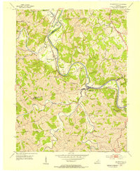
1953 Map of De Mossville
USGS Topo · Published 1955About this map
The Licking River winds deeply through the tri-county border of Kenton, Campbell, and Pendleton counties, defining a landscape of narrow ridges and sharp valley bends. During the early 1950s, the Louisville and Nashville railroad tracked the river’s western bank, serving riverside communities like Morning View and Kenton. These small settlements and rural crossroads are the heart of the map, anchored by local institutions such as St Marys Ch and Oak Island Ch.
Find a feature on this map
29 named features on this map. Tap any name to fly to it.
Don’t see what you’re looking for? This feature index may not catch every label — zoom into the map to look around manually.
Map Details
Editions of this 1953 De Mossville Map
This is the sole edition of this map. No revisions or reprints were ever made.
Other maps of this area

1929 · Alexandria
USGS Topo · 1:48,000

1930 · Falmouth
USGS Topo · 1:48,000

1936 · Alexandria
USGS Topo · 1:62,500

1936 · Falmouth
USGS Topo · 1:62,500

1950 · Williamstown
USGS Topo · 1:24,000

1950 · Independence
USGS Topo · 1:24,000

1950 · Walton
USGS Topo · 1:24,000

1953 · Butler
USGS Topo · 1:24,000

1953 · New Richmond
USGS Topo · 1:24,000
1953 · Alexandria
USGS Topo · 1:24,000