
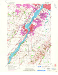
1954 Map of De Pere
USGS Topo · Published 1956About this map
The Fox River serves as the central artery for this mid-century landscape, where industrial development and educational institutions converge in the Fox River Valley. The core of De Pere and West De Pere is densely detailed, featuring the riverfront campus of St Norbert College and nearby Nicolet High Sch. Along the river's eastern bank, the Chicago Milwaukee St Paul and Pacific railroad tracks trace the shoreline past the State Reformatory and Minahan Stadium. To the south, the terrain opens into the rural tracts of Lawrence and Rockland, eventually reaching the historic river landing at Little Rapids and the grounds of Lost Dauphin State Park. This period of growth is reflected in the dual aviation facilities of Austin Straubel Airport and Nicolet Airport, while the margins of the settlements are dotted with numerous burial grounds like Woodlawn Cem and Allouez Cem.
Find a feature on this map
54 named features on this map. Tap any name to fly to it.
Don’t see what you’re looking for? This feature index may not catch every label — zoom into the map to look around manually.
Map Details
Editions of this 1954 De Pere Map
2 editions found
Other maps of this area

1954 · De Pere
USGS Topo · 1:62,500

1954 · Green Bay West
USGS Topo · 1:24,000

1954 · Denmark
USGS Topo · 1:62,500

1954 · New Franken
USGS Topo · 1:62,500

1954 · Green Bay East
USGS Topo · 1:24,000

1954 · Manitowoc
USGS Topo · 1:250,000

1954 · Bellevue
USGS Topo · 1:24,000

1954 · Green Bay
USGS Topo · 1:62,500

1955 · Green Bay
USGS Topo · 1:250,000

1958 · Manitowoc
USGS Topo · 1:250,000