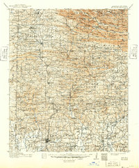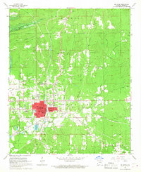
1966 Map of De Queen
USGS Topo · Published 1967About this map
De Queen serves as a critical junction in Sevier County, where the Kansas City Southern and De Queen and Eastern railroads intersect. This 1960s landscape shows a community in transition; blue hatching at the top of the sheet indicates areas planned for inundation by the De Queen Reservoir, a project that would permanently alter the course of Story Creek. The industrial footprint of the era is evident in the numerous Gravel Pit sites scattered north of town and the specialized development of Process City to the southwest.
Find a feature on this map
51 named features on this map. Tap any name to fly to it.
Don’t see what you’re looking for? This feature index may not catch every label — zoom into the map to look around manually.
Map Details
Editions of this 1966 De Queen Map
This is the sole edition of this map. No revisions or reprints were ever made.
Historical Maps of De Queen Through Time
8 maps found