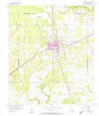
1956 Map of De Quincy
USGS Topo · Published 1957About this map
The railroad junction at De Quincy defines the landscape of Calcasieu Parish in the mid-1950s, where the Kansas City Southern and Missouri Pacific lines converge. This center of transit is flanked by the Louisiana Correctional Institute to the north and a developing industrial perimeter of energy extraction. The local economy is visibly rooted in the Perkins Oil and Gas Field and the North De Quincy Oil Field, marked by numerous well sites and storage facilities like the Oil Tank located near the town center.
Find a feature on this map
31 named features on this map. Tap any name to fly to it.
Don’t see what you’re looking for? This feature index may not catch every label — zoom into the map to look around manually.
Map Details
Editions of this 1956 De Quincy Map
3 editions found
Other maps of this area

1935 · Buhler
USGS Topo · 1:31,680

1935 · Gordon
USGS Topo · 1:31,680

1947 · DeQuincy
USGS Topo · 1:31,680

1947 · Sulphur Mines
USGS Topo · 1:31,680

1947 · Oretta
USGS Topo · 1:31,680

1947 · Kernan
USGS Topo · 1:31,680

1947 · Hyatt
USGS Topo · 1:31,680

1947 · Lunita
USGS Topo · 1:31,680

1947 · Long Marsh
USGS Topo · 1:31,680

1949 · Kernan
USGS Topo · 1:31,680