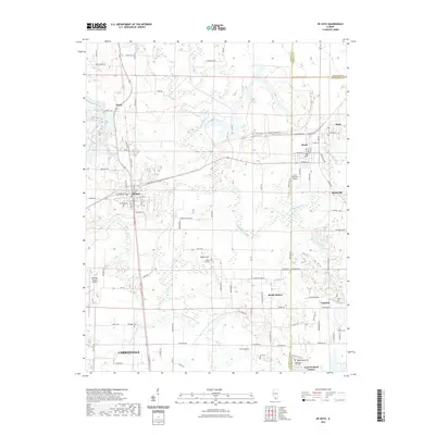
2021 Map of De Soto
USGS Topo · Published 2021About this map
Carbondale and its northern outskirts are shaped by the convergence of the Big Muddy River and its major tributaries, Crab Orchard Creek and the Little Muddy River. This 2021 landscape reflects decades of settlement and agricultural patterns along the Jackson and Williamson county lines, with established communities like De Soto and Hurst serving as local hubs. The terrain is marked by numerous family and community burial grounds, including Indian Hill Cem, Dillinger Cem, and McKinney Hill Cem, which provide essential touchpoints for genealogical research in the region. Transportation corridors such as N Illinois Ave and several namesake rural roads connect smaller settlements like Cambria, Blairsville, and Bush. A notable geographic feature is McKinney Hill, which overlooks the low-lying wetlands of the river system south of Hurst Rd.
Find a feature on this map
103 named features on this map. Tap any name to fly to it.
Don’t see what you’re looking for? This feature index may not catch every label — zoom into the map to look around manually.
Map Details
Editions of this 2021 De Soto Map
This is the sole edition of this map. No revisions or reprints were ever made.
Other maps of this area

1910 · Herrin
USGS Topo · 1:62,500

1910 · Murphysboro
USGS Topo · 1:62,500

1922 · Carbondale
USGS Topo · 1:62,500

1924 · Alto Pass
USGS Topo · 1:62,500

1936 · Herrin
USGS Topo · 1:62,500

1938 · Murphysboro
USGS Topo · 1:62,500

1941 · Carbondale
USGS Topo · 1:62,500

1947 · Alto Pass
USGS Topo · 1:62,500
1948 · Pomona
USGS Topo · 1:24,000
1949 · Alto Pass
USGS Topo · 1:62,500