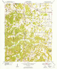
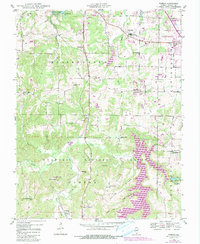
1948 Map of Pomona
USGS Topo · Published 1948About this map
The Mobile and Ohio RR cuts a path through the western Illinois hills, connecting the small settlements of Pomona and Etherton within a landscape defined by deep drainages and narrow ridges. The 1947 survey captures a rural Jackson County economy transitioning from small-scale farming and timber to regional connectivity via the Black Diamond Highway. Much of the southern half of the quadrangle lies within the Shawnee National Forest, where unique geological features like the Natural Bridge and Saltpeter Cave dot the rugged Cave Valley.
Find a feature on this map
55 named features on this map. Tap any name to fly to it.
Don’t see what you’re looking for? This feature index may not catch every label — zoom into the map to look around manually.
Map Details
Editions of this 1948 Pomona Map
5 editions found
Other maps of this area

1910 · Herrin
USGS Topo · 1:62,500

1910 · Murphysboro
USGS Topo · 1:62,500

1922 · Carbondale
USGS Topo · 1:62,500

1924 · Alto Pass
USGS Topo · 1:62,500

1936 · Herrin
USGS Topo · 1:62,500

1938 · Murphysboro
USGS Topo · 1:62,500

1941 · Carbondale
USGS Topo · 1:62,500

1947 · Alto Pass
USGS Topo · 1:62,500

1947 · Gorham
USGS Topo · 1:24,000
1947 · Wolf Lake
USGS Topo · 1:24,000