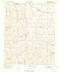
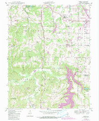
1948 Map of Pomona
USGS Topo · Published 1948About this map
Pomona and the small settlement of Etherton anchor this late 1940s landscape where rural life met industrial transport at the edge of the Shawnee National Forest. The Gulf Mobile and Ohio railroad corridor and the Black Diamond Highway reflect the region's historical connection to coal and trade, passing by landmarks like Sharon Sch and the Jenkins Sch. This area of southern Illinois shows a high density of community centers now valuable for genealogical research, including Mount Carbon Cem and several country churches such as Pleasant Grove Ch. In the southern hills, the terrain becomes more distinct with features like the Natural Bridge, Saltpeter Cave, and the winding Cave Creek. These features, along with numerous family-named landmarks like Bostick Cem and Ellis Ridge Sch, reveal the deep roots of the local farming and mining families before modern consolidation changed the rural school and church network.
Find a feature on this map
58 named features on this map. Tap any name to fly to it.
Don’t see what you’re looking for? This feature index may not catch every label — zoom into the map to look around manually.
Map Details
Editions of this 1948 Pomona Map
5 editions found
Other maps of this area

1910 · Herrin
USGS Topo · 1:62,500

1910 · Murphysboro
USGS Topo · 1:62,500

1922 · Carbondale
USGS Topo · 1:62,500

1924 · Alto Pass
USGS Topo · 1:62,500

1936 · Herrin
USGS Topo · 1:62,500

1938 · Murphysboro
USGS Topo · 1:62,500

1941 · Carbondale
USGS Topo · 1:62,500

1947 · Alto Pass
USGS Topo · 1:62,500

1947 · Gorham
USGS Topo · 1:24,000
1947 · Wolf Lake
USGS Topo · 1:24,000