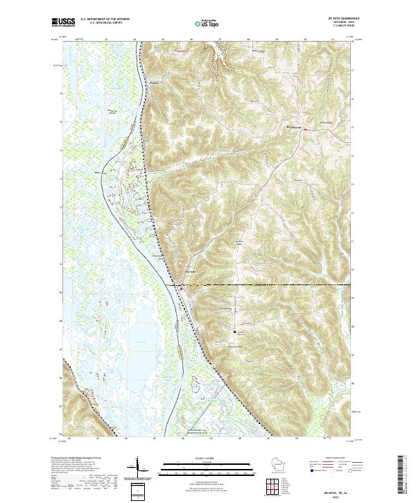
2022 Map of De Soto
USGS Topo · Published 2022About this map
The Mississippi River creates a complex landscape of islands and sloughs along the border of Iowa and Wisconsin, with the Winneshiek Bottoms dominating the river valley. The riverfront village of De Soto sits at the base of the steep Winneshiek Bluff, marking a transition from the waterway to the high ridges of Vernon County. The map details several landform features that recall the region's history, including Battle Hollow and Battle Slough, which refer to the 1832 conflict between the United States and the Sauk and Fox tribes. Inland from the river, the landscape is defined by agricultural settlements like Victory and Red Mound, connected by a network of winding ridge roads such as Victory Ridge and Asbury Ridge. Genealogists may find interest in the Lawrence Ridge Cem, located on the high ground of Lawrence Ridge between Howarth Ridge and the Vernon Co line.
Find a feature on this map
84 named features on this map. Tap any name to fly to it.
Don’t see what you’re looking for? This feature index may not catch every label — zoom into the map to look around manually.
Map Details
Editions of this 2022 De Soto Map
This is the sole edition of this map. No revisions or reprints were ever made.
Other maps of this area

1903 · Waukon
USGS Topo · 1:125,000

1926 · Stoddard
USGS Topo · 1:62,500

1929 · Ferryville
USGS Topo · 1:62,500

1932 · Ferryville
USGS Topo · 1:62,500

1956 · Brownsville
USGS Topo · 1:62,500

1958 · La Crosse
USGS Topo · 1:250,000

1961 · La Crosse
USGS Topo · 1:250,000

1965 · La Crosse
USGS Topo · 1:250,000
1965 · Stoddard
USGS Topo · 1:62,500

1966 · Ferryville
USGS Topo · 1:62,500