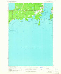
1964 Map of De Tour Village
USGS Topo · Published 1965About this map
De Tour Village serves as the gateway to the De Tour Passage and the shipping lanes of the Saint Marys River in this mid-1960s survey. Located at the southeastern tip of the Upper Peninsula, the village is defined by its maritime infrastructure, including the offshore De Tour Lighthouse and various navigation aids like Frying Pan Island. The surrounding landscape is largely protected by the Munuscong State Forest and De Tour State Park, reflecting the region's transition into a center for recreation and conservation. Genealogists can identify localized landmarks such as Maple Grove Cem and Bob Hill Cem, while the shoreline is dotted with family-named features like Olmstad Bay and Peters Island. The map also details several Gravel Pits and a Quarry, pointing to the local extraction industries that operated alongside the timber and maritime economy of the eastern UP.
Find a feature on this map
44 named features on this map. Tap any name to fly to it.
Don’t see what you’re looking for? This feature index may not catch every label — zoom into the map to look around manually.
Map Details
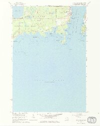
Editions of this 1964 De Tour Village Map
2 editions found
Other maps of this area

1954 · Alpena
USGS Topo · 1:250,000

1954 · Sault Sainte Marie
USGS Topo · 1:250,000

1955 · Cheboygan
USGS Topo · 1:250,000

1956 · Sault Sainte Marie
USGS Topo · 1:250,000

1957 · Alpena
USGS Topo · 1:250,000

1957 · Sault Sainte Marie
USGS Topo · 1:250,000

1958 · Cheboygan
USGS Topo · 1:250,000

1958 · Alpena
USGS Topo · 1:250,000

1958 · Sault Sainte Marie
USGS Topo · 1:250,000

1961 · Blind River
USGS Topo · 1:250,000
Featured Places
- De Tour Village, DeTour Village
- Detour Township, MI
- Drummond Township, MI
- DeTour Village, MI
- Chippewa County, MI