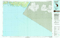
1984 Map of De Tour Village
USGS Topo · Published 1994About this map
Drummond Island and the strategic waters of the Saint Marys River define this mid-1980s survey of the northern Great Lakes borderland. The village of De Tour Village stands as a gateway at the De Tour Passage, where the mainland meets a complex network of islands and bays. Much of the land is preserved within the Lake Superior State Forest, showing a landscape dominated by inland lakes like Caribou Lake and Bear Lake alongside numerous points and coves including Seymour Point and Whitney Bay. The map documents the international boundary between Michigan and Ontario, tracing the line between the United States and Canada through Lake Huron. Small settlements like Cream City and Johnwood appear alongside industrial markings such as the Quarry on the island, illustrating the local economy's reliance on the region's natural resources and shipping lanes. The De Tour Lighthouse remains a critical maritime landmark for vessels navigating these heavy-traffic waters.
Find a feature on this map
82 named features on this map. Tap any name to fly to it.
Don’t see what you’re looking for? This feature index may not catch every label — zoom into the map to look around manually.
Map Details
Editions of this 1984 De Tour Village Map
2 editions found
Other maps of this area

1954 · Alpena
USGS Topo · 1:250,000

1954 · Sault Sainte Marie
USGS Topo · 1:250,000

1955 · Cheboygan
USGS Topo · 1:250,000

1956 · Sault Sainte Marie
USGS Topo · 1:250,000

1957 · Alpena
USGS Topo · 1:250,000

1957 · Sault Sainte Marie
USGS Topo · 1:250,000

1957 · Onaway
USGS Topo · 1:62,500

1958 · Cheboygan
USGS Topo · 1:250,000

1958 · Alpena
USGS Topo · 1:250,000

1958 · Sault Sainte Marie
USGS Topo · 1:250,000