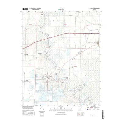
2017 Map of De Valls Bluff
USGS Topo · Published 2017About this map
De Valls Bluff sits at a historic crossing of the White River, serving as a focal point for this eastern Arkansas riverine landscape. The river's winding course is marked by numerous bends and points, including Coles Bend, Berden Slough Bend, and Dunns Shanty Point, illustrating the complex hydrology of the region. The map documents the spatial relationship between the river and several established communities, such as Hazen, Mesa, and Fredonia. The presence of the White River Bridge and the layout of local streets like Sycamore and Walnut in De Valls Bluff suggest a town structured by both its waterway and its terrestrial connections.
Find a feature on this map
109 named features on this map. Tap any name to fly to it.
Don’t see what you’re looking for? This feature index may not catch every label — zoom into the map to look around manually.
Map Details
Editions of this 2017 De Valls Bluff Map
This is the sole edition of this map. No revisions or reprints were ever made.
Other maps of this area

1935 · Hazen
USGS Topo · 1:62,500

1935 · Clarendon
USGS Topo · 1:62,500

1937 · Stuttgart
USGS Topo · 1:62,500

1939 · Stuttgart
USGS Topo · 1:62,500

1941 · Hazen
USGS Topo · 1:62,500

1941 · De Valls Bluff
USGS Topo · 1:62,500

1941 · Clarendon
USGS Topo · 1:62,500

1948 · Helena
USGS Topo · 1:250,000

1950 · Helena
USGS Topo · 1:250,000

1955 · Helena
USGS Topo · 1:250,000