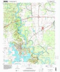
1996 Map of De Valls Bluff
USGS Topo · Published 1999About this map
De Valls Bluff sits at the center of this riverine landscape, where the White River meanders through a dense network of oxbow lakes and wetlands. The geography is defined by the shifting course of the river, leaving behind features like The Basin, Old River Lake, and Upshaw Lake. To the north and west, the Wattensaw State Wildlife Management Area preserves the bottomland hardwood environment, while elevated terrain like Pfenninghausen Ridge and Mesa provides a contrast to the surrounding floodplains.
Find a feature on this map
49 named features on this map. Tap any name to fly to it.
Don’t see what you’re looking for? This feature index may not catch every label — zoom into the map to look around manually.
Map Details
Editions of this 1996 De Valls Bluff Map
This is the sole edition of this map. No revisions or reprints were ever made.
Other maps of this area

1935 · Hazen
USGS Topo · 1:62,500

1935 · Clarendon
USGS Topo · 1:62,500

1937 · Stuttgart
USGS Topo · 1:62,500

1939 · Stuttgart
USGS Topo · 1:62,500

1941 · Hazen
USGS Topo · 1:62,500

1941 · De Valls Bluff
USGS Topo · 1:62,500

1941 · Clarendon
USGS Topo · 1:62,500

1948 · Helena
USGS Topo · 1:250,000

1950 · Helena
USGS Topo · 1:250,000

1955 · Helena
USGS Topo · 1:250,000