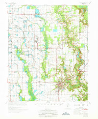
1970 Map of De Witt
USGS Topo · Published 1970About this map
De Witt serves as the focal point of this 1970 Arkansas survey, showcasing a landscape defined by organized agriculture and early aquaculture. The town center is densely detailed, featuring De Witt High Sch and the De Witt Airport, while the surrounding terrain is crisscrossed by an intricate network of flumes and irrigation canals supporting the region's rice-growing legacy. Notable specialized land use is evident at the Experimental Fish Farm and a nearby Fish Hatchery, indicating the industrial scale of local water management.
Find a feature on this map
36 named features on this map. Tap any name to fly to it.
Don’t see what you’re looking for? This feature index may not catch every label — zoom into the map to look around manually.
Map Details
Editions of this 1970 De Witt Map
This is the sole edition of this map. No revisions or reprints were ever made.
Other maps of this area

1935 · Varner
USGS Topo · 1:62,500

1935 · Clarendon
USGS Topo · 1:62,500

1935 · Gillett
USGS Topo · 1:62,500

1937 · Stuttgart
USGS Topo · 1:62,500

1939 · Indian Bay
USGS Topo · 1:62,500

1939 · Henrico
USGS Topo · 1:62,500

1939 · Stuttgart
USGS Topo · 1:62,500

1940 · Holly Grove
USGS Topo · 1:62,500

1941 · De Witt
USGS Topo · 1:62,500

1941 · Goldman
USGS Topo · 1:62,500