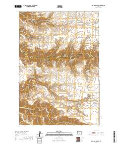
2020 Map of Dead Dog Canyon
USGS Topo · Published 2020About this map
Buzan Cem sits on the high ground between Salt Springs Canyon and Dead Dog Canyon, marking a quiet historical site in this remote stretch of Central Oregon. The landscape is defined by the sharp descent from the plateaus of Johnson Ridge and McLeod Ridge toward the winding channel of Buck Hollow Cr. This drainage serves as the boundary between Wasco and Sherman Counties, a natural border formed by deep erosion. Long-established routes such as Bakeoven Rd and Dugger Rd trace the contours of the high desert, providing access to isolated points like Sugarloaf. The map reveals an intricate network of seasonal drainages, including Bakeoven Cr and Smith Canyon, which have carved the terrain into a series of distinct ridges and draws that reflect the geological character of the region.
Find a feature on this map
29 named features on this map. Tap any name to fly to it.
Don’t see what you’re looking for? This feature index may not catch every label — zoom into the map to look around manually.
Map Details
Editions of this 2020 Dead Dog Canyon Map
This is the sole edition of this map. No revisions or reprints were ever made.
Other maps of this area

1930 · Dufur
USGS Topo · 1:125,000

1934 · Dufur
USGS Topo · 1:125,000

1953 · The Dalles
USGS Topo · 1:250,000

1956 · The Dalles
USGS Topo · 1:250,000

1957 · The Dalles
USGS Topo · 1:250,000

1962 · Sherars Bridge
USGS Topo · 1:24,000
1962 · Dant
USGS Topo · 1:24,000

1962 · Sinamox
USGS Topo · 1:24,000

1962 · Grass Valley
USGS Topo · 1:24,000
1962 · Maupin
USGS Topo · 1:24,000