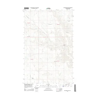
2014 Map of Dead Horse Coulee
USGS Topo · Published 2014About this map
Cottonwood Cr winds through the expansive drainage systems of Phillips County, carving a network of coulees that define this section of the Montana landscape. The topography is dominated by these deep seasonal channels, including the namesake Dead Horse Coulee and Bohner Coulee, which serve as critical markers in a region where water and relief are the primary navigational aids. This 2014 survey captures the rural infrastructure of the High Plains, where remote access is provided by unpaved routes such as Upper Frenchman Rd and the descriptively named Turkey Track Rd. The map illustrates the Public Land Survey System divisions between T35N and T36N, reflecting the geometric organization of ranching and grazing lands. Water features like E Fork Stinky Cr and Peck Coulee highlight the intricate hydrography that dictates the movement and settlement patterns across these vast, open ranges.
Find a feature on this map
13 named features on this map. Tap any name to fly to it.
Don’t see what you’re looking for? This feature index may not catch every label — zoom into the map to look around manually.
Map Details
Editions of this 2014 Dead Horse Coulee Map
This is the sole edition of this map. No revisions or reprints were ever made.
Other maps of this area

1954 · Glasgow
USGS Topo · 1:250,000

1957 · Glasgow
USGS Topo · 1:250,000

1958 · Glasgow
USGS Topo · 1:250,000

1984 · Thoeny Hills East
USGS Topo · 1:24,000

1984 · Forks
USGS Topo · 1:24,000

1984 · Coulter Coulee
USGS Topo · 1:24,000

1984 · Dead Horse Coulee
USGS Topo · 1:24,000

1984 · Crow Creek Dam
USGS Topo · 1:24,000
1984 · Thoeny Hills West
USGS Topo · 1:24,000
1984 · Salsbery Reservoir
USGS Topo · 1:24,000