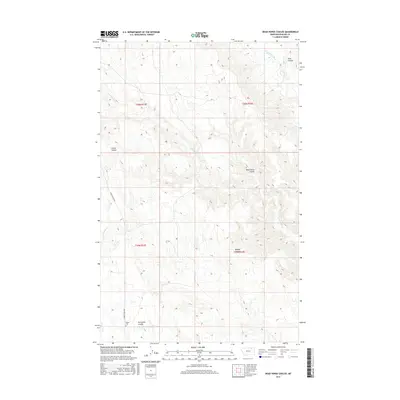
2017 Map of Dead Horse Coulee
USGS Topo · Published 2017About this map
Reitan Cem and the low-lying drainage of Porcupine Coulee define the southern landscape of this Phillips County territory. The terrain is deeply carved by a network of seasonal watercourses and drainage channels, with Frenchman Creek flowing through the northeast corner while Cottonwood Cr and E Fork Stinky Cr mark the western reaches. This 2017 survey reflects a remote grazing and ranching landscape where infrastructure is sparse, dominated primarily by named geological depressions like Dead Horse Coulee and Bohner Coulee. The primary transit through this high-plains environment is Turkey Track Rd, which winds through the western townships of t36n r33e and t35n r33e. For researchers, the map provides a precise layout of the Public Land Survey System grid across this intersection of townships, documenting the few established landmarks in a region defined by its topography.
Find a feature on this map
14 named features on this map. Tap any name to fly to it.
Don’t see what you’re looking for? This feature index may not catch every label — zoom into the map to look around manually.
Map Details
Editions of this 2017 Dead Horse Coulee Map
This is the sole edition of this map. No revisions or reprints were ever made.
Other maps of this area

1954 · Glasgow
USGS Topo · 1:250,000

1957 · Glasgow
USGS Topo · 1:250,000

1958 · Glasgow
USGS Topo · 1:250,000

1984 · Thoeny Hills East
USGS Topo · 1:24,000

1984 · Forks
USGS Topo · 1:24,000

1984 · Coulter Coulee
USGS Topo · 1:24,000

1984 · Dead Horse Coulee
USGS Topo · 1:24,000

1984 · Crow Creek Dam
USGS Topo · 1:24,000
1984 · Thoeny Hills West
USGS Topo · 1:24,000
1984 · Salsbery Reservoir
USGS Topo · 1:24,000