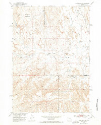
1951 Map of Dead Indian Hill
USGS Topo · Published 1974About this map
Dead Indian Hill and the surrounding drainage of Fifteen Mile Creek define this section of the Big Horn Basin during the early 1950s. The map illustrates a landscape primarily used for ranching and livestock, evidenced by seasonal habitations and stock management features like the Wagon Hound Bedground and Horseshoe Bedground. Numerous individual dwellings and sheep camps are noted, including the Mc Donald Cabins, Green Cabin, and the already Kemick Cabin (Aband). Water management is critical in this arid terrain, with several small catchments such as School Section Reservoir and Asays Reservoir situated near deep draws and gulches. The convergence of Park, Big Horn, and Washakie counties at the southern edge of the sheet highlights the remote intersection of these regional jurisdictions.
Find a feature on this map
22 named features on this map. Tap any name to fly to it.
Don’t see what you’re looking for? This feature index may not catch every label — zoom into the map to look around manually.
Map Details
Editions of this 1951 Dead Indian Hill Map
2 editions found
Other maps of this area

1951 · Hillberry Rim
USGS Topo · 1:24,000

1951 · Dutch Nick Flat SW
USGS Topo · 1:24,000

1951 · Gillies Draw
USGS Topo · 1:24,000

1951 · Sheep Mountain
USGS Topo · 1:24,000

1951 · Tatman Mountain
USGS Topo · 1:24,000

1951 · Sheets Flat
USGS Topo · 1:24,000

1951 · Wilson Spring
USGS Topo · 1:24,000

1951 · Dead Indian Hill
USGS Topo · 1:24,000

1951 · Dutch Nick Flat NW
USGS Topo · 1:24,000

1955 · Cody
USGS Topo · 1:250,000