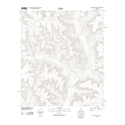
2010 Map of Dead Man Canyon
USGS Topo · Published 2010About this map
The Pecos River carves a deep path through this segment of the West Texas landscape, serving as the primary drainage for an intricate system of dry canyons. The terrain is defined by a series of dramatic, steep-walled formations including First Canyon, Second Canyon, and Third Canyon which feed into the river valley from the east. This 2010 survey illustrates the isolation and topographic complexity of the region, where water management is critical to the sparse human presence. Evidence of ranching infrastructure is found at Dead Man Windmill, situated near the head of Dead Man Canyon. The map reveals the relationship between the narrow river corridor and the expansive Reagan Canyon system, highlighting the extreme relief that dictates movement across this portion of Crockett County.
Find a feature on this map
7 named features on this map. Tap any name to fly to it.
Don’t see what you’re looking for? This feature index may not catch every label — zoom into the map to look around manually.
Map Details
Editions of this 2010 Dead Man Canyon Map
This is the sole edition of this map. No revisions or reprints were ever made.
Other maps of this area

1929 · Sheffield
USGS Topo · 1:125,000

1954 · Sonora
USGS Topo · 1:250,000

1958 · Sonora
USGS Topo · 1:250,000

1967 · Burnt Canyon
USGS Topo · 1:24,000

1967 · Fort Lancaster
USGS Topo · 1:24,000

1967 · Bachelor Hill
USGS Topo · 1:24,000

1967 · Sheffield SE
USGS Topo · 1:24,000

1967 · Dead Man Canyon
USGS Topo · 1:24,000
1967 · Sheffield
USGS Topo · 1:24,000
1970 · Prince Albert Draw
USGS Topo · 1:24,000