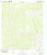
1979 Map of Dead Mans Pass
USGS Topo · Published 1979About this map
Dead Mans Pass stands as a prominent point of orientation in this arid reach of Val Verde County, where a complex network of dry drainages and steep ridges defines the West Texas landscape. The 1970s topography reveals a remote territory largely governed by the passage of water through systems like Dead Mans Canyon, Crazy Canyon, and Cow Creek. Evidence of human activity is sparse but telling, characterized by scattered Tanks, isolated wells, and a single Landing Strip carved out of the plateau. This isolated airfield and the presence of names like Mc Nutt suggest a ranching economy reliant on small-scale aviation and carefully managed water sources. The map also traces the distinct routes through high ground at Sevenmile Gap and Rattlesnake Gap, highlighting the natural corridors used to navigate this broken terrain.
Find a feature on this map
15 named features on this map. Tap any name to fly to it.
Don’t see what you’re looking for? This feature index may not catch every label — zoom into the map to look around manually.
Map Details
Editions of this 1979 Dead Mans Pass Map
This is the sole edition of this map. No revisions or reprints were ever made.
Other maps of this area

1941 · Feely
USGS Topo · 1:62,500

1943 · Shumla
USGS Topo · 1:62,500

1944 · Mouth Of Pecos
USGS Topo · 1:62,500

1944 · Baker Crossing
USGS Topo · 1:62,500

1958 · Del Rio
USGS Topo · 1:250,000

1964 · Del Rio
USGS Topo · 1:250,000

1972 · Seminole Canyon
USGS Topo · 1:24,000
1972 · Gillis Ranch
USGS Topo · 1:24,000
1972 · Comstock
USGS Topo · 1:24,000
1979 · Telephone Canyon
USGS Topo · 1:24,000