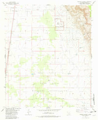
1981 Map of Deadman Canyon
USGS Topo · Published 1982About this map
The Southern Pacific railroad corridor defines the western edge of this desert landscape, passing through the settlement of Valmont and by a quiet Roadside Park. This 1981 edition shows the intersection of federal land management and infrastructure, where the White Sands National Monument and Ruins sit adjacent to the vast Fort Bliss Military Reservation (McGregor Range). To the east, the topography shifts dramatically into the Lincoln National Forest, marked by the steep descents of Dog Canyon and Deadman Canyon. Water management in this arid environment is evident through several named sources like Tony Tank, Laney Spring, and Langford Windmill. The map captures a moment when traditional ranching landmarks like the Fairchild Well existed alongside significant military and conservation boundaries.
Find a feature on this map
22 named features on this map. Tap any name to fly to it.
Don’t see what you’re looking for? This feature index may not catch every label — zoom into the map to look around manually.
Map Details
Editions of this 1981 Deadman Canyon Map
This is the sole edition of this map. No revisions or reprints were ever made.
Other maps of this area

1916 · Point Of Sands
USGS Topo · 1:125,000

1948 · Tres Hermanos
USGS Topo · 1:62,500

1948 · Holloman
USGS Topo · 1:62,500

1950 · Escondido Canyon
USGS Topo · 1:62,500

1950 · Alamogordo
USGS Topo · 1:62,500

1954 · Carlsbad
USGS Topo · 1:250,000

1955 · Las Cruces
USGS Topo · 1:250,000

1958 · Las Cruces
USGS Topo · 1:250,000

1958 · Carlsbad
USGS Topo · 1:250,000

1976 · Mule Peak
USGS Topo · 1:24,000