
1976 Map of Mule Peak
USGS Topo · Published 1980About this map
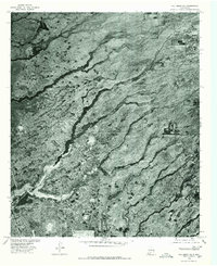
Omlee sits at the base of the dramatic escarpment that dominates the eastern half of this 1976 orthophotograph. This specialized survey, produced by the Geological Survey in cooperation with the Soil Conservation Service, captures the landscape of Otero County through rectified aerial imagery rather than traditional topographic lines. The imagery reveals the sharp transition between the flat basin floor and the deeply incised drainage systems of the mountains, including Mule Canyon and San Andres Canyon. High points like Mule Peak overlook the narrow transit corridor where rail and road infrastructure follow the mountain's edge. The detailed photography provides a clear view of land use patterns, from the organized grid near the settlement to the natural alluvial fans spreading from Dog Canyon and Alamo.
Find a feature on this map
6 named features on this map. Tap any name to fly to it.
Don’t see what you’re looking for? This feature index may not catch every label — zoom into the map to look around manually.
Map Details
Editions of this 1976 Mule Peak Map
This is the sole edition of this map. No revisions or reprints were ever made.
Other maps of this area

1916 · Point Of Sands
USGS Topo · 1:125,000

1948 · Tres Hermanos
USGS Topo · 1:62,500

1948 · Holloman
USGS Topo · 1:62,500

1950 · Escondido Canyon
USGS Topo · 1:62,500

1950 · Alamogordo
USGS Topo · 1:62,500

1954 · Carlsbad
USGS Topo · 1:250,000

1955 · Las Cruces
USGS Topo · 1:250,000

1958 · Las Cruces
USGS Topo · 1:250,000

1958 · Carlsbad
USGS Topo · 1:250,000
1976 · Holloman NE
USGS Topo · 1:24,000