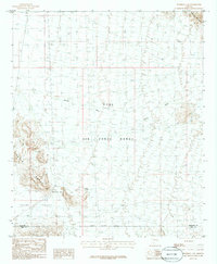
1986 Map of Deadman Gap
USGS Topo · Published 1986About this map
Luke Air Force Range dominates this southwestern Arizona landscape, reflecting the mid-20th-century expansion of military training grounds in the Sonoran Desert. The map captures a largely arid and unpopulated expanse where topographic features like the Crater Range and the Sauceda Mountains provide the primary landmarks for navigation. The namesake Deadman Gap serves as a natural corridor between the volcanic heights of the Crater Range and the lower reaches of Childs Valley, illustrating how geology dictated movement through these desert flats. Evidence of human presence is sparse and functional, concentrated at the small settlement of Midway and the White Tank water source. A solitary Corral and scattered 4wd tracks trace the minimal infrastructure used for ranching or military patrols, while Midway Wash cuts a seasonal drainage path across the basin toward the Maricopa and Pima county line.
Find a feature on this map
13 named features on this map. Tap any name to fly to it.
Don’t see what you’re looking for? This feature index may not catch every label — zoom into the map to look around manually.
Map Details
Editions of this 1986 Deadman Gap Map
This is the sole edition of this map. No revisions or reprints were ever made.
Other maps of this area

1932 · Ajo
USGS Topo · 1:62,500

1934 · Ajo
USGS Topo · 1:62,500

1953 · Ajo
USGS Topo · 1:250,000

1957 · Ajo
USGS Topo · 1:250,000

1958 · Ajo
USGS Topo · 1:250,000

1958 · Midway
USGS Topo · 1:62,500

1958 · Hat Mountain
USGS Topo · 1:62,500

1962 · Ajo
USGS Topo · 1:250,000

1963 · Ajo
USGS Topo · 1:250,000

1963 · Ajo
USGS Topo · 1:62,500