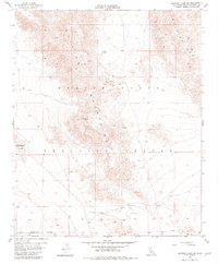
1955 Map of Deadman Lake SE
USGS Topo · Published 1982About this map
The Bullion Mountains dominate this arid landscape, showing a region defined by high-altitude peaks and military utility during the mid-1950s. The presence of the Marine Corps Training Center across a large portion of the quadrangle highlights the area's shift toward intensive military use, punctuated by a Rifle Range and a network of Jeep Trails that negotiate the steep terrain. On the western edge, the dry bed of Deadman Lake provides a stark contrast to the surrounding elevations, including notable survey markers like VABM Segundo 3463 and Usmm 108. Evidence of prospecting activity is scattered throughout the hills, with several Prospects and a Gravel Pit noted, indicating small-scale mineral exploration typical of the Mojave's interior ranges during this era.
Find a feature on this map
13 named features on this map. Tap any name to fly to it.
Don’t see what you’re looking for? This feature index may not catch every label — zoom into the map to look around manually.
Map Details
Editions of this 1955 Deadman Lake SE Map
5 editions found
Other maps of this area

1942 · Amboy
USGS Topo · 1:250,000

1943 · Amboy
USGS Topo · 1:250,000

1953 · San Bernardino
USGS Topo · 1:250,000

1954 · Needles
USGS Topo · 1:250,000

1954 · Valley Mtn
USGS Topo · 1:24,000

1955 · Deadman Lake NW
USGS Topo · 1:24,000

1955 · Lead Mountain
USGS Topo · 1:24,000

1955 · Deadman Lake SE
USGS Topo · 1:24,000

1955 · Deadman Lake NE
USGS Topo · 1:24,000

1955 · Deadman Lake SW
USGS Topo · 1:24,000