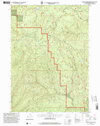
1998 Map of Deadman Mountain
USGS Topo · Published 2000About this map
Deadman Mountain rises as the central topographic anchor in this portion of the Umpqua National Forest, a landscape defined by its complex network of steep drainages and logging history. Mining activity is evident in the southern terrain, where the Umpqua Mine and Maude S Mine are situated along the lower slopes. The water system is particularly dense, with Deadman Creek, South Myrtle Creek, and the Middle Fork carving through the mountains.
Find a feature on this map
25 named features on this map. Tap any name to fly to it.
Don’t see what you’re looking for? This feature index may not catch every label — zoom into the map to look around manually.
Map Details
Editions of this 1998 Deadman Mountain Map
This is the sole edition of this map. No revisions or reprints were ever made.
Other maps of this area

1891 · Ashland
USGS Topo · 1:250,000

1893 · Ashland
USGS Topo · 1:250,000

1897 · Roseburg
USGS Topo · 1:125,000

1897 · Ashland
USGS Topo · 1:250,000

1900 · Roseburg
USGS Topo · 1:125,000

1904 · Riddle
USGS Topo · 1:125,000

1944 · Tiller
USGS Topo · 1:62,500

1954 · Dixonville
USGS Topo · 1:62,500

1954 · Days Creek
USGS Topo · 1:62,500

1955 · Red Butte
USGS Topo · 1:62,500