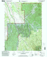
1998 Map of Deadman Mountain
USGS Topo · Published 2001About this map
Wasatch National Forest dominates this landscape along the Wyoming and Utah border, where the High Uintas' drainage systems form a complex network of irrigation and recreation. The Bear River serves as a primary corridor, flanked by the Mirror Lake Scenic Byway and supported by infrastructure like the Hilliard East Fork Canal and Hilliard West Side Canal. This 1990s revision details a high-elevation environment transitioning from working landscapes like Burts-Miller Ranch and Island Ranch to federal management at the Bear River Ranger Station. Notable for local history and public land researchers, the map includes the Hill Air Force Base Recreation Camp and several seasonal sites including the Bear River Snowpark and East Fork Campground. Distinctive peaks such as Lone Mountain and Deadman Mountain anchor the terrain, while numerous small water bodies like Lily Lake and Grassu Lakes dot the forest floor.
Find a feature on this map
33 named features on this map. Tap any name to fly to it.
Don’t see what you’re looking for? This feature index may not catch every label — zoom into the map to look around manually.
Map Details
Editions of this 1998 Deadman Mountain Map
This is the sole edition of this map. No revisions or reprints were ever made.
Other maps of this area

1885 · Uinta
USGS Topo · 1:250,000

1901 · Hayden Peak
USGS Topo · 1:125,000

1903 · Hayden Peak
USGS Topo · 1:125,000

1954 · Salt Lake City
USGS Topo · 1:250,000

1954 · Ogden
USGS Topo · 1:250,000

1958 · Ogden
USGS Topo · 1:250,000

1958 · Salt Lake City
USGS Topo · 1:250,000

1960 · Ogden
USGS Topo · 1:250,000

1960 · Salt Lake City
USGS Topo · 1:250,000

1965 · Myers Reservoir
USGS Topo · 1:24,000