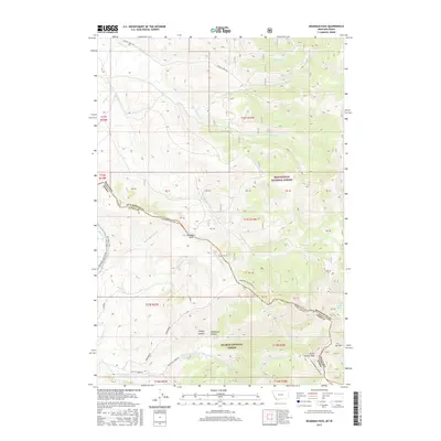
2017 Map of Deadman Pass
USGS Topo · Published 2017About this map
Continental Divide NST snakes across the high terrain of this borderlands region, where the high ridges of the Bitterroot Range separate the Beaverhead National Forest in Montana from the Salmon National Forest in Idaho. At the center of this remote landscape lies Deadman Pass, a crossing point flanked by deep drainages like Deadhorse Canyon and Rough Canyon. The map reveals a complex network of watercourses, from the headwaters of Horse Prairie Creek to the isolated Dad Cr Lake near Elk Mtn. This modern survey documents the contemporary management of these public lands, showing established access routes such as Railroad Canyon Rd and the Nez Perce NHT, reflecting the intersection of natural geography and long-standing historical transit corridors through the northern Rockies.
Find a feature on this map
35 named features on this map. Tap any name to fly to it.
Don’t see what you’re looking for? This feature index may not catch every label — zoom into the map to look around manually.
Map Details
Editions of this 2017 Deadman Pass Map
This is the sole edition of this map. No revisions or reprints were ever made.
Other maps of this area

1955 · Dubois
USGS Topo · 1:250,000

1956 · Leadore
USGS Topo · 1:62,500

1956 · Morrison Lake
USGS Topo · 1:62,500

1958 · Dubois
USGS Topo · 1:250,000

1965 · Deadman Pass
USGS Topo · 1:24,000

1965 · Jeff Davis Peak
USGS Topo · 1:24,000
1965 · Hansen Ranch
USGS Topo · 1:24,000
1965 · Everson Creek
USGS Topo · 1:24,000

1965 · Bannock Pass
USGS Topo · 1:24,000
1965 · Medicine Lodge Peak
USGS Topo · 1:24,000