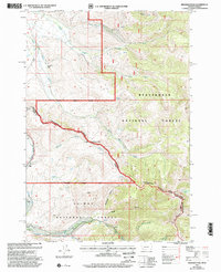
1997 Map of Deadman Pass
USGS Topo · Published 2002About this map
The Continental Divide forms a high-altitude spine across this landscape, serving as the jagged border between Beaverhead County, Montana, and Lemhi County, Idaho. This 1990s survey documents a region defined by its role as a passage through the Bitterroot Range, anchored by Deadman Pass and several significant trails. The Nez Perce (Ne-Me-Poo) National Historic Trail follows the ridge alongside the Continental Divide Scenic Trail, marking a path of immense cultural and historical weight. To the west, the Salmon National Forest drops away through deep drainages like Deadhorse Canyon and Rough Canyon, while the eastern slopes fall toward the L-Diamond Ranch and the headwaters of Colorado Creek. The map provides a look at the intersection of the Dillon Ranger District and Leadore Ranger District, where alpine features like Dad Creek Lake and Elk Mountain sit along the high crest.
Find a feature on this map
29 named features on this map. Tap any name to fly to it.
Don’t see what you’re looking for? This feature index may not catch every label — zoom into the map to look around manually.
Map Details
Editions of this 1997 Deadman Pass Map
This is the sole edition of this map. No revisions or reprints were ever made.
Other maps of this area

1955 · Dubois
USGS Topo · 1:250,000

1956 · Leadore
USGS Topo · 1:62,500

1956 · Morrison Lake
USGS Topo · 1:62,500

1958 · Dubois
USGS Topo · 1:250,000

1965 · Deadman Pass
USGS Topo · 1:24,000

1965 · Jeff Davis Peak
USGS Topo · 1:24,000
1965 · Hansen Ranch
USGS Topo · 1:24,000
1965 · Everson Creek
USGS Topo · 1:24,000

1965 · Bannock Pass
USGS Topo · 1:24,000
1965 · Medicine Lodge Peak
USGS Topo · 1:24,000