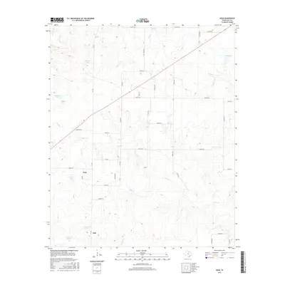
2016 Map of Dean
USGS Topo · Published 2016About this map
The community of Dean and the nearby settlement of Jolly anchor this north-central Texas landscape, characterized by a complex network of farm-to-market roads and seasonal watercourses. The drainage of Turkey Cr and Bennett Cr winds through the terrain, punctuated by several private reservoirs and stock tanks including Bridwell Lake, Ferguson Lake, and Householder Lake. The area's agricultural and rural residential patterns are clearly defined by the grid of local roads like W Gaines Rd, Watkins Rd, and Shawnee Trl. The map illustrates the contemporary rural infrastructure of Clay County, showing how modern land use persists around the older established communities of Dean and Jolly. Small-scale water management is evident in the naming of Dowdy Lake Number 1 and Dowdy Lake Number 2, highlighting the importance of localized water storage in this part of the state.
Find a feature on this map
43 named features on this map. Tap any name to fly to it.
Don’t see what you’re looking for? This feature index may not catch every label — zoom into the map to look around manually.
Map Details
Editions of this 2016 Dean Map
This is the sole edition of this map. No revisions or reprints were ever made.
Other maps of this area

1954 · Wichita Falls
USGS Topo · 1:250,000

1955 · Lawton
USGS Topo · 1:250,000

1956 · Sloop Creek
USGS Topo · 1:24,000

1956 · Henrietta
USGS Topo · 1:62,500

1957 · Hastings
USGS Topo · 1:62,500

1957 · Randlett
USGS Topo · 1:62,500

1957 · Wichita Falls East
USGS Topo · 1:62,500

1957 · Wichita Falls East
USGS Topo · 1:24,000

1958 · Wichita Falls
USGS Topo · 1:250,000
1972 · Dean
USGS Topo · 1:24,000