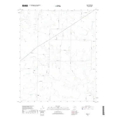
2019 Map of Dean
USGS Topo · Published 2019About this map
Dean and Jolly anchor this portion of Clay County, characterized by a complex network of creeks and small private reservoirs. The drainage patterns of Turkey Cr, Hay Cr, and Bennett Cr define the rolling terrain, feeding into various named water bodies such as Bridwell Lake, Householder Lake, and Ferguson Lake. The land is segmented by a grid of rural roads, many bearing family names that reflect the local agricultural history, including Taylor Rd, Watkins Rd, and Moore Rd. Notably, the presence of Shawnee Trl suggests the path of earlier historic routes through the region. This 2019 survey captures the modern rural landscape, showing the density of farm-to-market access through FM 2393 and the continued importance of water management in this Texas prairie environment.
Find a feature on this map
36 named features on this map. Tap any name to fly to it.
Don’t see what you’re looking for? This feature index may not catch every label — zoom into the map to look around manually.
Map Details
Editions of this 2019 Dean Map
This is the sole edition of this map. No revisions or reprints were ever made.
Other maps of this area

1954 · Wichita Falls
USGS Topo · 1:250,000

1955 · Lawton
USGS Topo · 1:250,000

1956 · Sloop Creek
USGS Topo · 1:24,000

1956 · Henrietta
USGS Topo · 1:62,500

1957 · Hastings
USGS Topo · 1:62,500

1957 · Randlett
USGS Topo · 1:62,500

1957 · Wichita Falls East
USGS Topo · 1:62,500

1957 · Wichita Falls East
USGS Topo · 1:24,000

1958 · Wichita Falls
USGS Topo · 1:250,000
1972 · Dean
USGS Topo · 1:24,000