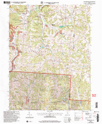
2002 Map of Deavertown
USGS Topo · Published 2006About this map
Wayne National Forest land dominates the southern portion of this Perry and Morgan County landscape, where the coal and oil heritage of the region remains clearly visible. Numerous Strip Mines are scattered across the terrain, particularly near Misco and Tropic, reflecting the intensive resource extraction that defined this part of Ohio. The drainage patterns of Black Fork and Moxahala Creek dictate the layout of small settlements like Rose Farm and Milligan, which sit tucked into the valleys between the wooded ridges.
Find a feature on this map
52 named features on this map. Tap any name to fly to it.
Don’t see what you’re looking for? This feature index may not catch every label — zoom into the map to look around manually.
Map Details
Editions of this 2002 Deavertown Map
This is the sole edition of this map. No revisions or reprints were ever made.
Other maps of this area

1910 · Philo
USGS Topo · 1:62,500

1910 · Zanesville
USGS Topo · 1:62,500

1910 · Mc Connelsville
USGS Topo · 1:62,500

1911 · New Lexington
USGS Topo · 1:62,500

1947 · Columbus
USGS Topo · 1:250,000

1949 · Clarksburg
USGS Topo · 1:250,000

1956 · Clarksburg
USGS Topo · 1:250,000

1961 · Columbus
USGS Topo · 1:250,000

1961 · Clarksburg
USGS Topo · 1:250,000

1961 · Corning
USGS Topo · 1:24,000