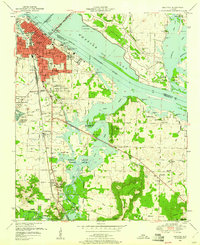
1950 Map of Decatur
USGS Topo · Published 1960About this map
Wheeler Lake dominates this mid-century landscape, where the Limestone and Morgan County line follows the submerged channel of the Tennessee River. The city of Decatur is shown at a pivotal moment of post-war growth, characterized by a dense grid of red-tinted urban streets and industrial infrastructure including a brick kiln, filtration beds, and the Keller Memorial Bridge. Beyond the city limits, the landscape transitions into the expansive Wheeler National Wildlife Refuge, which protects the wetlands of Flint Creek and Blue Hole.
Find a feature on this map
67 named features on this map. Tap any name to fly to it.
Don’t see what you’re looking for? This feature index may not catch every label — zoom into the map to look around manually.
Map Details
Editions of this 1950 Decatur Map
3 editions found
Other maps of this area

1888 · Cullman
USGS Topo · 1:125,000

1888 · Huntsville
USGS Topo · 1:125,000

1892 · Cullman
USGS Topo · 1:125,000

1892 · Huntsville
USGS Topo · 1:125,000

1935 · Danville
USGS Topo · 1:48,000

1936 · Hartselle
USGS Topo · 1:24,000

1936 · Decatur
USGS Topo · 1:24,000

1936 · Stewart Cross Roads
USGS Topo · 1:24,000

1936 · Trinity
USGS Topo · 1:24,000

1936 · Somerville
USGS Topo · 1:24,000