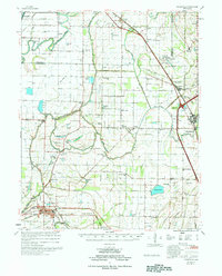
1977 Map of Deckerville
USGS Topo · Published 1977About this map
The St Francis River and the Tyronza River define the intricate hydrology of this eastern Arkansas landscape, where an extensive network of drainage projects like Ditch No 44 and Ditch No 13 has reshaped the bottomlands for agriculture. This mid-1970s survey captures a rural environment characterized by small agricultural hubs and a dense distribution of country churches and family-named cemeteries. Settlements like Deckerville, Gilmore, and Earle are connected by both the St Louis San Francisco RR and the Missouri Pacific RR, reflecting the region's reliance on rail transport for moving timber and crops. The eastern edge of the map is dominated by the Wapanocca National Wildlife Refuge, preserving a fragment of the native terrain near Turrell against the backdrop of the modernizing Interstate 55 corridor.
Find a feature on this map
120 named features on this map. Tap any name to fly to it.
Don’t see what you’re looking for? This feature index may not catch every label — zoom into the map to look around manually.
Map Details
Editions of this 1977 Deckerville Map
This is the sole edition of this map. No revisions or reprints were ever made.
Other maps of this area

1916 · Memphis
USGS Topo · 1:62,500

1925 · Memphis
USGS Topo · 1:48,000

1927 · Memphis
USGS Topo · 1:62,500

1931 · Jericho
USGS Topo · 1:62,500

1939 · Jericho
USGS Topo · 1:62,500

1939 · Edmondson
USGS Topo · 1:62,500

1939 · Memphis
USGS Topo · 1:62,500

1939 · Evadale
USGS Topo · 1:62,500

1940 · Deckerville
USGS Topo · 1:62,500

1940 · Princedale
USGS Topo · 1:62,500