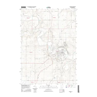
2015 Map of Decorah
USGS Topo · Published 2015About this map
The Upper Iowa River winds through the heart of this landscape, carving a valley that defines the local geography. The city of Decorah is established along its banks, notably adjacent to landmarks like Pulpit Rock and the campus of Luther Coll. The river's influence is evident in the numerous crossings and island features, including Steyer Bridge and the central Goose Island. To the north, Malanaphy Springs highlights the area's hydrology, while the surrounding township boundaries of t98n r8w and t99n r8w contain a network of rural roads such as Bluffton Rd and Scenic River Rd. Researchers will find several burial grounds documented throughout the county, including Saint Benedict Cem near the city center and the more outlying Union Prairie Cem. Tributaries like Dry Run, Trout Run, and Canoe Cr further segment the terrain, illustrating the complex drainage patterns of Winneshiek County.
Find a feature on this map
98 named features on this map. Tap any name to fly to it.
Don’t see what you’re looking for? This feature index may not catch every label — zoom into the map to look around manually.
Map Details
Editions of this 2015 Decorah Map
This is the sole edition of this map. No revisions or reprints were ever made.
Other maps of this area

1906 · Decorah
USGS Topo · 1:125,000

1958 · La Crosse
USGS Topo · 1:250,000

1961 · La Crosse
USGS Topo · 1:250,000

1965 · La Crosse
USGS Topo · 1:250,000

1975 · Decorah 4 NW
USGS Topo · 1:24,000

1975 · Decorah 1 NW
USGS Topo · 1:24,000

1975 · Decorah 2 NW
USGS Topo · 1:24,000

1975 · Decorah 1 SW
USGS Topo · 1:24,000

1975 · Decorah 3 NW
USGS Topo · 1:24,000
1975 · Decorah 2 NE
USGS Topo · 1:24,000