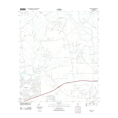
2012 Map of Dedeaux
USGS Topo · Published 2012About this map
Diamondhead dominates the southwestern portion of this coastal Mississippi landscape, featuring an intricate network of residential streets and golf course fairways. The terrain transitions from the densely developed community of Diamondhead into more rural areas to the north and east, where the small settlement of Dedeaux is positioned near the intersection of several local roads. The natural hydrography is a defining element of the region, with Rotten Bayou and Bayou Lasalle weaving through the central wetlands. Further east, the Wolf River flows toward the Saint-Louis-Bay, creating a complex system of marshes and inlets such as Pickens Lagoon. Local history is anchored by sites like Saint Joseph Cem and Sand Hill Cem, while the eastern edge includes the community of De Lisle, marking the transition toward the larger bay area.
Find a feature on this map
189 named features on this map. Tap any name to fly to it.
Don’t see what you’re looking for? This feature index may not catch every label — zoom into the map to look around manually.
Map Details
Editions of this 2012 Dedeaux Map
This is the sole edition of this map. No revisions or reprints were ever made.
Other maps of this area

1953 · Mobile
USGS Topo · 1:250,000

1954 · McHenry
USGS Topo · 1:62,500

1955 · Savannah
USGS Topo · 1:62,500

1955 · Pass Christian
USGS Topo · 1:24,000

1956 · Bay St. Louis
USGS Topo · 1:24,000

1956 · Vidalia
USGS Topo · 1:24,000

1956 · Waveland
USGS Topo · 1:24,000

1956 · Gulfport NW
USGS Topo · 1:24,000

1957 · Mobile
USGS Topo · 1:250,000
1959 · Kiln
USGS Topo · 1:24,000