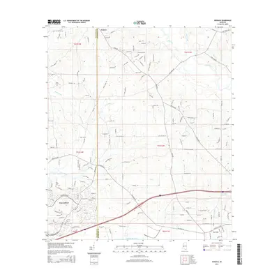
2015 Map of Dedeaux
USGS Topo · Published 2015About this map
Wolf River and its intricate drainage network, including Sandy Creek and Rotten Bayou, dominate the landscape of coastal Mississippi in this mid-2010s survey. The area transitions from the more densely developed planned community of Diamondhead in the southwest toward the rural settlements of Dedeaux and De Lisle. The terrain is characterized by numerous small waterways like Mill Cr and Coon Br that feed into the larger bayous and ultimately toward the Gulf of Mexico. Historical sites of interest for local researchers include Sand Hill Cem and Saint Joseph Cem, which serve as quiet markers of the region's long-standing families. A dense grid of local roads, such as Kiln-Delisle Rd and Fenton Dedeaux Rd, provides access across the shifting boundaries of Hancock Co and Harrison County, illustrating the modern connectivity of these historic gulf coast townships.
Find a feature on this map
98 named features on this map. Tap any name to fly to it.
Don’t see what you’re looking for? This feature index may not catch every label — zoom into the map to look around manually.
Map Details
Editions of this 2015 Dedeaux Map
This is the sole edition of this map. No revisions or reprints were ever made.
Other maps of this area

1953 · Mobile
USGS Topo · 1:250,000

1954 · McHenry
USGS Topo · 1:62,500

1955 · Savannah
USGS Topo · 1:62,500

1955 · Pass Christian
USGS Topo · 1:24,000

1956 · Bay St. Louis
USGS Topo · 1:24,000

1956 · Vidalia
USGS Topo · 1:24,000

1956 · Waveland
USGS Topo · 1:24,000

1956 · Gulfport NW
USGS Topo · 1:24,000

1957 · Mobile
USGS Topo · 1:250,000
1959 · Kiln
USGS Topo · 1:24,000