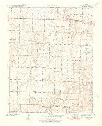
1939 Map of Dederick
USGS Topo · Published 1954About this map
Handley Prairie and the undulating plains of Vernon County define this 1939 landscape, where the Kansas City Southern railroad cuts a straight line through the northern territory. The settlement of Dederick sits along this rail line, serving as a hub for the surrounding rural townships of Walker, Badger, and Virgil. The map reveals a high density of one-room schoolhouses that once anchored these farming communities, including Mobley Sch, Green Springs Sch, and Round Prairie Sch, reflecting the decentralized nature of rural education before mid-century consolidation.
Find a feature on this map
29 named features on this map. Tap any name to fly to it.
Don’t see what you’re looking for? This feature index may not catch every label — zoom into the map to look around manually.
Map Details
Editions of this 1939 Dederick Map
2 editions found
Other maps of this area

1886 · Nevada
USGS Topo · 1:125,000

1894 · Nevada
USGS Topo · 1:125,000

1933 · Camp Clark
USGS Topo · 1:24,000

1938 · Horton
USGS Topo · 1:24,000

1939 · Horton
USGS Topo · 1:24,000

1939 · Dederick
USGS Topo · 1:24,000

1939 · Eldorado Springs North
USGS Topo · 1:24,000
1939 · Harwood
USGS Topo · 1:24,000

1939 · Eldorado Springs South
USGS Topo · 1:24,000
1940 · Harwood
USGS Topo · 1:24,000