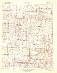
1942 Map of Dederick
USGS Topo · Published 1942About this map
The agrarian community of Dederick anchors this pre-war landscape in Vernon County, where the Kansas Texas and Missouri railroads converge. This era of rural education is remarkably preserved, showing an extensive network of schoolhouses including Mobley Sch, Badger Sch, Green Springs Sch, and Willow Grove Sch. The topography reveals a land defined by its drainages, with Clear Creek and the West Fork carving through the countryside. Evidence of local industry and community life appears in the Culbertson Mine and several rural cemeteries like Stepp Cem and Sandstone Cem. State Geologist H. A. Buehler oversaw this 1939 survey, which provides a precise record of farmsteads and township boundaries across Handley Prairie and into Montevallo.
Find a feature on this map
31 named features on this map. Tap any name to fly to it.
Don’t see what you’re looking for? This feature index may not catch every label — zoom into the map to look around manually.
Map Details
Editions of this 1942 Dederick Map
2 editions found
Other maps of this area

1886 · Nevada
USGS Topo · 1:125,000

1894 · Nevada
USGS Topo · 1:125,000

1933 · Camp Clark
USGS Topo · 1:24,000

1938 · Horton
USGS Topo · 1:24,000

1939 · Horton
USGS Topo · 1:24,000

1939 · Dederick
USGS Topo · 1:24,000

1939 · Eldorado Springs North
USGS Topo · 1:24,000
1939 · Harwood
USGS Topo · 1:24,000

1939 · Eldorado Springs South
USGS Topo · 1:24,000
1940 · Harwood
USGS Topo · 1:24,000