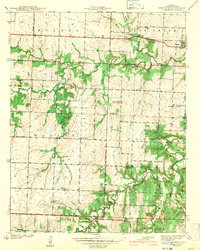
1942 Map of Dederick
USGS Topo · Published 1942About this map
Walker Prairie dominates the northern landscape of this Missouri quadrangle, where the Missouri Kansas Texas railroad cuts a straight line through the settlement of Dederick. The area is characterized by a dense network of early rural institutions, with schoolhouses like Mobley Sch, Badger Sch, and Green Springs Sch serving dispersed farming communities. Religious and memorial sites, including Oak Ridge church and Sandstone Cem, are tucked away near the winding path of Clear Creek.
Find a feature on this map
30 named features on this map. Tap any name to fly to it.
Don’t see what you’re looking for? This feature index may not catch every label — zoom into the map to look around manually.
Map Details
Editions of this 1942 Dederick Map
2 editions found
Other maps of this area

1886 · Nevada
USGS Topo · 1:125,000

1894 · Nevada
USGS Topo · 1:125,000

1933 · Camp Clark
USGS Topo · 1:24,000

1938 · Horton
USGS Topo · 1:24,000

1939 · Horton
USGS Topo · 1:24,000

1939 · Dederick
USGS Topo · 1:24,000

1939 · Eldorado Springs North
USGS Topo · 1:24,000
1939 · Harwood
USGS Topo · 1:24,000

1939 · Eldorado Springs South
USGS Topo · 1:24,000
1940 · Harwood
USGS Topo · 1:24,000